Peter Calthorpe in Urbanism in the Age of Climate Change (2011) makes a convincing argument that urbanism needs to be a major component of society’s efforts to control greenhouse gas emissions. He compares high density city environments with moderate density, close-in suburbs, and finally with further-out, low density suburbs. The annual carbon emissions per household are 6 metric tons in the city, 10 metric tons in the close-in suburbs, and 21 metric tons in the low density suburbs (Calthorpe 2011, plates 4 and 5).
A suburban house can be made greener and the cars used to get around can be made more efficient, reducing energy use by about 30 percent (Table 29.1). A townhome in a close in neighborhood with public transit uses 38 percent less energy than a low density suburban house, even without solar panels or a super-efficient car. With a greener house and car, a close-in household uses 58 percent less than a suburban household. If an urban living unit is made more energy efficient and a more energy efficient car is used, the green urban existence uses 74 percent less energy than a suburban house (Calthorpe 2011, 19). These are significant reductions in energy use and, therefore, greenhouse gas reductions. The smaller energy use of urban living also translates into smaller utility bills and fewer new power generation plants. Urbanism reduces carbon footprint and is less expensive for the people living there and for the society as a whole (Calthorpe 2011, 10).
The current population of the United States is 296 million people, and we emit 23 metric tons of carbon per person per year. The population is growing at a rate that will add an additional 130 million people by 2050. Climate science suggests that we need to reduce energy use to 20 percent of our 1990 levels by 2050 to control greenhouse warming. This reduction, combined with population growth, means we need to reduce our per capita energy use to 12 percent of our current energy use (Calthorpe 2011, 8). If policy changes could move more of the population toward green urban living we would be well on our way to the 12 percent goal. Green urban living uses 25.8 percent of the current energy use of suburban living. Urban growth patterns can take us halfway with efficiencies in other sectors of the economy filling in the other half (Calthorpe 2011, 116).
TABLE 29.1 Household energy use for the outer suburban sprawl, the inner compact suburbs, and the urban core in MBtu/year
Cars | House | Total | Percent | |
Suburban | 237 | 152 | 399 | 100 |
Green Suburban | 158 | 113 | 271 | 69.4 |
Compact Suburb | 119 | 126 | 245 | 61.4 |
Green Compact Suburb | 79 | 88 | 167 | 41.8 |
Urban | 71 | 80 | 151 | 37.8 |
Green Urban | 47 | 56 | 103 | 25.8 |
Source: Calthorpe 2011, plate 3.
To create a new urban way of life it is necessary to rethink how zoning and policy direct our attention to forms. Neighborhoods are the core concept with their interconnected walkable streets leading to a commercial core. Town and city centers are the next scale up and are connected to the neighborhoods by light rail and bus transit systems. Corridors connect the region together. Corridors are roads, regional and local transit, rivers, and power distribution. Preservers set aside natural features of the region, and, finally, districts collect large entities like airports and big box stores (Calthorpe 2011, 64). Human scale, from how houses and streets interact to how people get around the neighborhood and city, should be the guiding design principle. Diversity of building types at the residential and retail commercial scale provides a more usable community close at hand. Conservation calls for greener buildings that use fewer resources along with saving historical fabric and natural features (Calthorpe 2011, 53–55).
Human scale, diversity, and conservation as overreaching concepts can be applied at the neighborhood, city, and regional scales. Walkable streets at the neighborhood level become light rail and bus transit at the city scale and regional rapid transit at the regional scale (Figures 29.1 and 29.2). Clustered urbanism forms around the transit stops at a variety of appropriate scales (Calthorpe 2011, 56). This is a fractal concept. Fractal geometry is the study of self-similar shapes. Learning how to see with a fractal eye opens up a deeper awareness of the structure of natural and man-made systems. See Chapter 8 on nature’s geometry.
Urbanism starts with the neighborhood. A neighborhood is a collection of housing with convenience retail and commercial business at its core. The size of a neighborhood is defined by Andres Duany as a 5 minute walk (Duany et al. 2010, 6.1). Others set the size at a 10 minute walk (Calthorpe 1993, 56). Either way, a neighborhood is more defined by its center than by its outside edge (Duany et al. 2010, 6.2). Actually at the outside edge there will be a fuzzy border between different neighborhoods. Housing density and diversity are important components for the support of a retail center that can provide at least some of the daily shopping needs of the community. Schools are a very important component of neighborhood. The grammar schools are the glue that connects the parents of the children together, often creating lifetime friendships. Middle and high schools usually collect from multiple neighborhoods and thus provide cross neighborhood connections. A dense neighborhood needs a collection of small parks of about one-quarter acre (Duany et al. 2010, 6.3). Related to these parks and possibly encompassing them, the natural features of an area should be preserved. This should include water drainage streams and wetlands, stands of trees, and high and low points of the site (Duany et al. 2010, 4.1–4.8). The street structure should provide multiple connections and multiple paths between the parts of the neighborhood. This usually means some form of a grid of streets and modest block size. The grid should also have multiple connections to other neighborhoods and the region (Duany et al. 2010, 7.1–7.4).
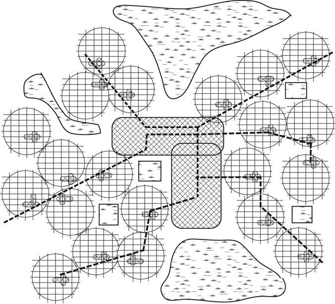
FIGURE 29.1 Neighborhoods connected together by a transit system become towns and cities less dependent on the automobile.
In and around neighborhoods there are typically three street types (Figure 29.3). Streets designed for easy flow of traffic, with parallel parking on both sides and two 10 foot wide travel lanes striped for clarity, are connecting streets between neighborhoods. Inside neighborhoods, there are two street sizes, streets that still provide enough room for cars traveling in both directions, with parallel parking on both sides but with 8 foot travel lanes, which slows the traffic down, and streets serving the lower density housing in the neighborhood, providing only room for one car to pass if cars are parallel parked on both sides of the street (Duany et al. 2010, 8.9–8.11). Sidewalks sheltered from the moving cars with parallel parked cars and/or street trees are important to street life. In commercial areas, sidewalks should be 15 to 25 feet wide without obstructions (Duany et al. 2010, 9.1–9.6). A range of building types from apartments through to condos, townhouses, and small lot to larger lot houses needs to be provided to accommodate a diverse population (Duany et al. 2010, 12.2–12.8).
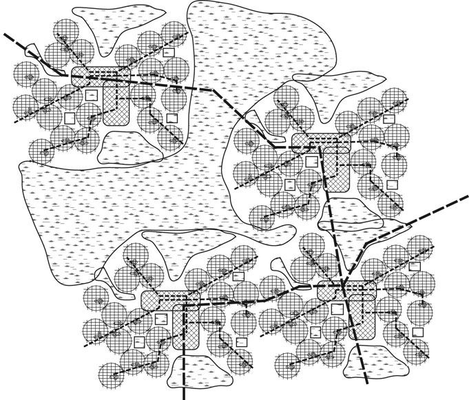
FIGURE 29.2 The cities and towns of an urban area connected together by an urban transit system reduce strain on the highway system and reduce the energy footprint of the urban dweller.
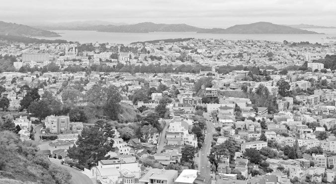
FIGURE 29.3 Dense neighborhoods in San Francisco demonstrate the mix of street sizes from connector streets to narrow neighborhood streets. Photo by Carl Bovill.